

Satellite Remote Sensing for Monitoring Urban Heat Islands
 As summer approaches and heatwaves become more frequent, cities worldwide experience record-breaking temperatures that put people’s health and even lives at risk. Global warming is also exacerbated by the urban heat island effect, which is being monitored using Earth observation satellite data and discussed by Elzė Buslavičiūtė and Dr Laurynas Jukna, geographers from the Department of Geography and Land Management of Vilnius University (VU).
More than half the world’s population lives in cities
Although for most of our history, humans lived in low-density settlements, by 2009, the urban population had surpassed the number of people living in rural areas, while today, more than half of humanity lives in cities. We all notice, particularly in summer, that temperatures in urban areas tend to be higher than in the surrounding suburbs and villages. Various studies have shown that air temperature differences between urban and rural areas can be as much as 2–4 degrees. Scientists have been aware of this phenomenon, also known as a heat island, since the early 19th century.
In cities, heat islands are caused not only by the thermal properties of concrete or asphalt surfaces but also by the urban configuration, which leads to changes in air circulation, as well as by the lack of vegetation providing a cooling effect.
With an ageing population, rapid urbanisation, and ongoing climate change, urban areas pose higher risks to our health. Heat-related mortality rates are growing every year. In addition to its life-threatening risks, heat also alters people’s behaviours by reducing their physical activity and affecting productivity.
Monitoring urban heat islands from satellites
The formation of heat islands is usually monitored by measuring temperature differences, e.g. by comparing meteorological data from cities and their suburbs or by systematically using vehicle-based temperature measurements in different parts of urban areas.
One of the newest methods for monitoring thermal distribution is satellite remote sensing. Satellite data has made measuring the urban heat island effect much easier, as they point to increasing near‐surface, rather than air, temperatures. The measurements are made using mid- and far-infrared sensors installed on Earth observation satellites, which also capture thermal infrared radiation (wavelengths of 3–14 micrometres) within these bands. For example, NASA Landsat’s thermal infrared imagery indicates the average summer surface temperatures in Lithuania’s territory from 2021 to 2023: it is evident that the major cities – Vilnius, Kaunas, and Klaipėda – have the highest average temperatures, while the surrounding areas are cooler on average.
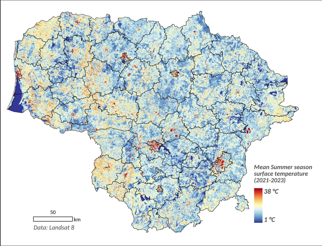
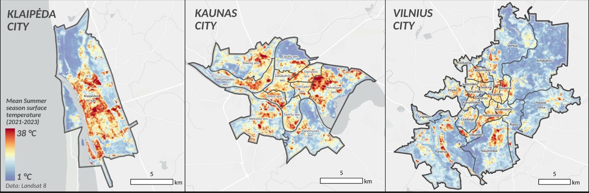
A closer look at Lithuania’s major cities shows that industrial and commercial areas have the highest average temperatures, with the greatest building density and the lowest surface albedo of the abundant artificial surfaces (albedo is a measure of the proportion of incident light or radiation that is reflected by a surface). For instance, the highest average summer surface temperatures are observed in the following parts of Vilnius: Šiaurės miestelis (the North Town), industrial and commercial areas near Vilnius Airport, and Savanorių Avenue. This is in contrast to green spaces, such as Vingis Park, Paneriai, and Verkiai Regional Park, which boast a cooling effect.
Adaptability of urban areas
Although the urban heat island effect has become more apparent in recent years, this issue can be mitigated through urban greening, appropriate building materials, controlled urban expansion, and water bodies. For example, surface reflectivity (albedo) in urban areas is one of the most important factors behind the heat island effect. Increasing reflectivity, e.g. by painting surfaces white, can reduce urban air temperatures by 1–3°C.
Urban greening, including urban forests and parks, is another heat-mitigation strategy. By enhancing evapotranspiration rates and shading, greening can achieve localised cooling within 2–3 m from the surface. However, despite all these multiple measures in place, urban planning solutions cannot completely eliminate the risk of extreme heatwaves. This year, for example, Delhi has set a heat record when the temperatures hovered around 50°C. Thus, heat-health warning systems have emerged as a critical tool for managing urban heat risks. Such systems, used in Philadelphia (USA) and Shanghai (China), combined with the installation of cooling centres and drinking water stations, along with the provision of information to vulnerable groups, have helped reduce heat-related mortality.